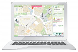
InterGIS is an Interactive City Information System that combines a directory of enterprises and a detailed map of the city.
InterGIS:
- A detailed map of Kaliningrad city in Kaliningrad region
- A universal directory of enterprises
- Up-to-date information
- Free distribution
- A reference map of InterGIS is available for free downloading.
About the Programme
Inter GIS is a convenient, fast and efficient tool
Inter GIS is an Interactive City Information System that combines a directory of enterprises and an electronic map of the city enabling the clients to see not only the contact details of your firm but also its whereabouts on the map. An electronic system of Inter GIS allows for a quick and easy search for your company’s contact details, including its name, address, telephone or scope of activity. It may also help you select the required route of public transport and see it on the map.
The essential benefit of InterGIS electronic directory lies in information updates on a monthly basis. Thus, the database is updated with entries of new firms, at the same time, the previously made entries of companies can be amended and revised and new objects can be placed on the map. If there is any piece of data to be changed the relevant organization will need just to get in contact with InterGIS and inform it about this and these changes will be considered in the next revision of the directory.
A reference map of InterGIS is an effective product that enables the user to save time and money and help the buyer and the seller encounter each other.
What is crucial for us is to make information you deal with up-to-date and reliable. To make you avoid using stale data InterGIS service functions will automatically end in four month from the last update.
For free downloads of a new edition of InterGIS reference map go to InterGIS.ru
